- Deforestation is surging around Indigenous reserves in Brazil’s agricultural heartland, threatening one of the last stretches of preserved rainforest in the region.
- The destruction is trickling into protected areas too, including Capoto/Jarina Indigenous Territory, home to Brazil’s most famous Indigenous leader.
- Indigenous advocates blame land speculation on the back of plans to pave a stretch of the MT-322 highway, which runs across the Capoto/Jarina and Xingu Indigenous Park.
- Indigenous people worry the road will ease access into their territories, opening them up to land-grabbers, wildcat miners and organized crime groups.
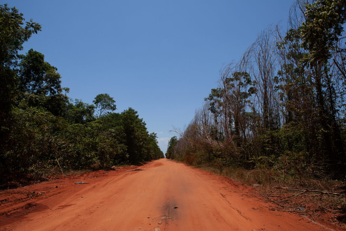
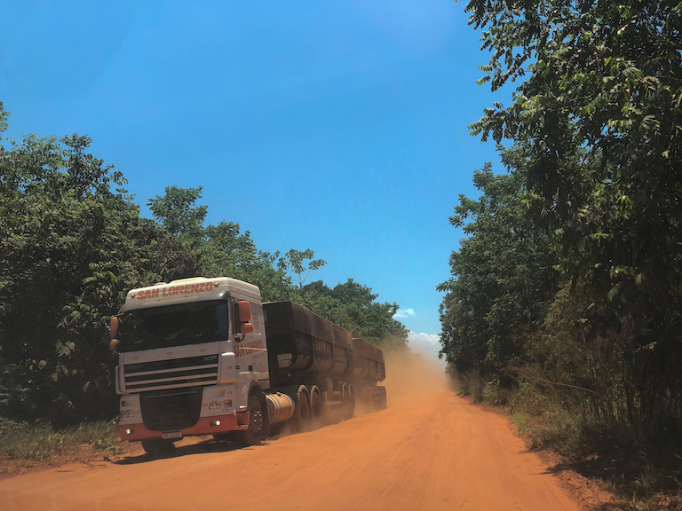
PEIXOTO DE AZEVEDO, Brazil — The red dirt road cuts through the jungle like a fresh wound, splintering one of Brazil’s most pristine stretches of Amazon rainforest. Clouds of dust rise above the emerald canopy, as roaring freight trucks loaded with soybeans plow through deep craters of hardened mud.
On one side lies the Xingu Indigenous Park, the country’s oldest demarcated reserve. Across the road is the Capoto/Jarina Indigenous Territory, home to Brazil’s best-known Indigenous leader, Raoni Metuktire, who famously walked with president Luiz Inacio Lula da Silva on inauguration day on Jan. 1, in a symbol of new beginnings for the Amazon and its people.
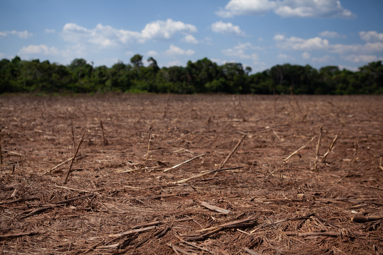
Together, these two Indigenous territories form a vast oasis of rainforest stretching 3.3 million hectares across the state of Mato Grosso, Brazil’s agricultural heartland. But all around them, the forest is giving way to soy plantations and cattle pastures at a breakneck pace.
“We’re surrounded here,” says Puiú Txukarramãe, Raoni’s nephew and a leader, or cacique, from the Kayapó Indigenous people, who live in Capoto/Jarina. “Inside our area, it’s all forest. Outside of it, it’s all farms. There are farms everywhere you look.”

The region is home to around 7,480 Indigenous people from 18 different groups, who rely on the rainforest for hunting, fishing and traditional rituals. Both Indigenous reserves have been under strict federal protection for decades. But, as agriculture has swallowed up the rainforest around their territories, their communities have come under increasing pressure too.
In the municipality of Peixoto de Azevedo, where the majority of the Capoto/Jarina reserve lies, the forest destruction is advancing at a dizzying rate. Between January 1 and October 26, satellites detected 804,094 high-confidence deforestation alerts within the municipality’s primary forest, according to data from the University of Maryland visualized on Global Forest Watch.
Much of this deforestation is clustered around Capoto/Jarina, with vast, rectangular patches of forest cleared in recent months — a hallmark of soy’s expansion. And there are signs the destruction is trickling into the reserve to0: satellite data and imagery show clearings proliferating along its border in 2023, as well as burn scars from forest fires.
Now, advocates worry pressure on Capoto/Jarina could intensify amid plans to pave the road, known as MT-322, running along the reserve’s border, while also building a bridge extending it across the Xingu River. Indigenous leaders say the project, lauded by agribusiness, would fuel deforestation around their lands and open them up to land-grabbers, gold-miners and organized crime groups seeking new drug routes through the forest.
“This is the biggest problem we’re facing right now,” said a local source at Funai, the federal agency tasked with protecting Brazil’s Indigenous people, who requested anonymity. “People are worried about how this will affect their villages. They’re worried about the animals crossing the road, the forest around the territory.”

Already, the project has sparked a wave of land speculation, according to Indigenous rights groups, with farmers scrambling to snap up vast plots of land on the margin of the Indigenous territories. The scramble for land is clear along one stretch of the MT-322: just before the limits of Capoto/Jarina, a fence circles miles of virgin rainforest, possibly destined to be razed.
“The deforestation is coming full steam,” said Karina Paço, executive director of the Amazonas Institute, a nonprofit group working with Indigenous people in this region. “And Indigenous people are trapped in the midst of it.”
Road to destruction
The area around Capoto/Jarina was once blanketed by a thick canopy of rainforest. But that began to change in the 1970s, with the construction of a major federal highway that would eventually morph into the MT-322.
The 827-km road was part of an ambitious plan to populate the vast Amazon rainforest, hatched by the military dictatorship that governed Brazil at the time. Fearing invasions on its sovereignty, it beckoned newcomers to the “land without men for men without land.”
“This region was largely cut off until then,” said Ivar Busatto, general coordinator of Operação Amazônia Nativa (OPAN), a nonprofit focused on Indigenous rights. “It was practically impossible to reach.”
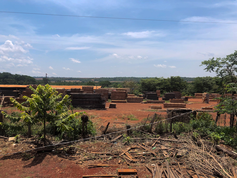
Lured by promises of opportunity, migrants from across Brazil flooded this region. Loggers ventured deep into the rainforest in search of valuable tree varieties, felling trees that had stood for centuries. Wildcat miners drilled into the mineral-rich soil, hoping to strike gold. Others razed vast patches of forest, turning them into cattle pastures and plantations.

A progression of satellite imagery from Google Timelapse shows how the forests of northern Mato Grosso have been whittled away by industry over the past four decades.

The outsiders soon descended on the Kayapo people’s ancestral lands, wreaking havoc. “They lived inside the territory, there was a whole town there,” said Paço. “There was an oil well, a prison — they had everything.” The barge, used to cross the Xingu River until today, was built and run by the outsiders back then, she added.
The newcomers also brought along disease, violence and rampant deforestation. “Soon, the measles came, then the flu — so many people were dying,” Paço added. “So the Indigenous people said, ‘that’s enough’.”
In a clash that would become known as the “Battle for the Barge,” the Kayapó people expelled the outsiders from Capoto/Jarina and took control of the barge crossing. Led by Chief Raoni, Indigenous leaders traveled to Brasilia to plead for demarcation. In 1984, the land was recognized as an Indigenous reserve, gaining full federal protection in the early 1990s.
But the MT-322, carved into the heart of the forest two decades earlier without consent from Indigenous people, continued to operate and fuel tensions. When Indigenous people tried to limit access during the pandemic, two armed men fired nearly 30 shots at a barrier blocking the road and stormed into the village of Piaraçu, threatening Indigenous residents.
“This was always an area of conflict,” Paço said. “This project just brought a whole new set of problems.”
In Mato Grosso, where agriculture is the economic engine, pressure is mounting to improve this treacherous stretch of the highway – despite the risks it may pose to the rainforest and the people who live in it. Proponents of the project argue asphalting the road and building a bridge would speed up the transport of grains, ushering in economic growth.
“What we’re seeing happening is this clash of forces,” said Busatto. “Development is at odds with preservation of protected lands.”
In September, Brazil’s main environmental agency, Ibama, began the licensing process for the paving of a 514-km section of the road, including the stretch running along the border of Capoto/Jarina. It is also reviewing the plans to construct the bridge, which would replace the barge currently operated by Indigenous people.

Despite repeated requests by Indigenous people and environmental advocates, federal and state authorities have never carried out studies to understand the MT-322’s impacts on the flora and fauna in the region. Ibama did not respond to a request for comment on the project’s impacts.
“We, the Indigenous peoples of Xingu, are not against the economic development of the region,” over two dozen Indigenous leaders said in an open letter last year, demanding impact studies before the project moves forward. “But we do not accept construction at any cost.”
Their main worry is that paving of the road would make entry into their territory that much easier, opening the floodgates to more forest destruction. Without the barge, the community would also struggle to keep invaders out of the Indigenous village of Piraraçu, which lies on the other side of the Xingu River.
“We have the right to live in peace on our ancestral lands,” said Puiú.“That’s all we’re asking of the government — and of the world too. We just want to be left in peace.”
The cost of progress
In this corner of Mato Grosso, the traces of an agricultural boom are everywhere. At the airport in Sinop, a city that has been catapulted to growth by soy and cattle, a huge sign welcomes visitors to the “agribusiness capital of Brazil.”

Across the city, billboards advertise cutting-edge farming equipment and high-grade animal feed. Streets are lined with shiny, new buildings housing commodities giants like Amaggi, Cargill and Bunge. At sundown, freight trucks loaded with soy and corn clog the roads slicing through town.
“Agriculture is what moves the economy here,” said Busatto. “It’s seen as the future.”
Mato Grosso, Brazil’s biggest producer of agricultural goods, churned out nearly $35 billion dollars in agricultural products last year — and alone accounted for a quarter of the country’s soy production. Corn, soy and cattle produced here travel to Brazilian ports thousands of miles away, before they are shipped onwards to China, Europe and the United States.
Here, government and business are placing big bets on agriculture. In hopes of moving grains more efficiently and boosting exports, authorities plan to build a 1,000-kilometer railway connecting Sinop to Itaituba, a port town in Pará. The railway, which has been marred by legal trouble, would bite into an important protected forest if it moves ahead as planned.
Notably, authorities plan to build a railway station in Matupá, where the MT-322 road begins. State governor Mauro Mendes says paving the road is “highly strategic” and would connect the region to important export routes, including the new railway and the BR-163. He has argued that this would consolidate Mato Grosso’s role as an agricultural powerhouse.
Even without environmental licensing, paving of some sections of the road has already started. “This is the moment a lot of people have been waiting for,” Mendes said in a livestream in August, as a truck poured asphalt onto a section of MT-322. The project, he said, would improve “the quality of life of the people who live in peace here, allowing progress to continue.”
For Milton José Dalmolin, vice-president of the Mixed Agricultural Cooperative of Terra Nova (Coopernova), the project would be a game changer. Currently, freight trucks headed to ports in Brazil’s northeast make detours of hundreds of miles due to poor roads. Laying asphalt and building a bridge would make the transport of goods faster, cheaper and safer, Dalmolin explained.
“It cuts 2,000 kilometers from the journey,” he told Mongabay in the cooperative’s office in the town of Terra Nova do Norte, which translates to “New Land of the North.” “The asphalting of the road won’t deforest, it won’t interfere with the reserve. Nothing will change.”
Still, he recognized that improved logistics along this stretch of the MT-322 highway could also open up the region to ill-intentioned “adventurers,” seeking to deforest or invade Indigenous lands. But he insisted Indigenous people should not allow outsiders to “corrupt” their communities, while federal authorities must do more to police protected lands.
“We need to live with preservation — but we need to produce food too,” Dalmolin said. “So we have to find a balance.”
Looming threat
Just outside Capoto/Jarina, a battered sign sits propped up on a wooden fence. Instead of signaling the limits of an Indigenous reserve, it warns visitors to keep out of the “Fazenda Conquista” (“conquest” in Portuguese). Across the road, a handful of straw-covered huts, built decades ago by Indigenous people, languish abandoned.
“There used to be an Indigenous village there,” said cacique Puiú. “They left and built homes deeper into our area. Because they ended up practically glued to the road.”
He noted invasions from nearby farms remain a constant worry for Indigenous people in Capoto/Jarina. “We’re keeping a close eye,” Puiú said. “It could happen at any time.”

Officially, the responsibility for policing reserves like Capoto/Jarina falls on Funai. But, after years of budget cuts under former president Jair Bolsonaro, the agency has struggled to recover its enforcement prowess. While deforestation in the Amazon as a whole has fallen by two-thirds this year, it has continued undeterred in some regions, like Mato Grosso state.
“For now, we have no resources for inspections,” said the Funai source, noting that the regional team hasn’t received funding for fuel, making policing operations into Capoto/Jarina impossible. “So our hands are tied.”
In the meantime, Indigenous people have taken matters into their own hands. The Raoni Institute, which represents the Kayapó people, has trained two surveillance teams, tasking them with patrolling the Capoto/Jarina territory.
Within the limits of the reserve, much of the rainforest remains intact. But, along the MT-322, it’s clear the destruction is inching closer. On a recent drive, our car bounced past toppled trees. The dense forest flanking the road was parched, after weeks without rain. In one stretch, the vegetation was charred by fire.
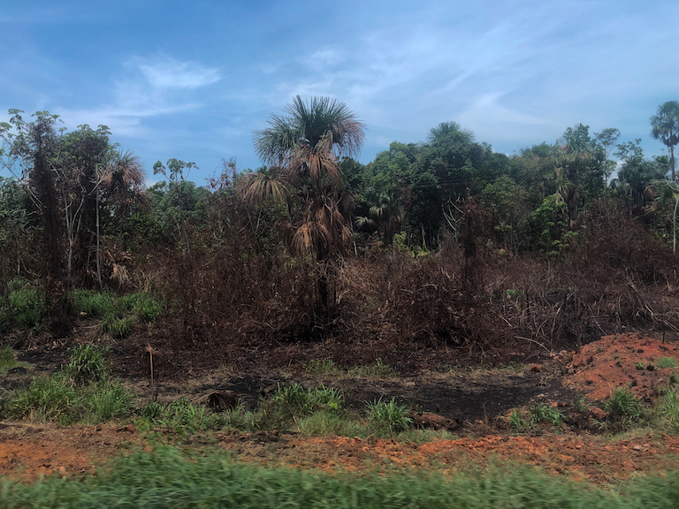
As soy replaces trees, the remaining rainforest is drying out, making it vulnerable to wildfires started on nearby farms. In 2022, fires consumed 3.5 million hectares in Mato Grosso, more than anywhere else in the Brazilian Amazon.
Even though burning is banned during the dry season, farmers often use slash-and-burn techniques to renew degraded pastures or prepare lots for planting. These fires can spread far beyond the limits of the farm, engulfing parched forest in nearby reserves like Capoto/Jarina.
“We never imagined that such violent fires could reach the villages,” Paço said. “Now it’s happening practically every year. Is it unintentional? Yes, in a way. But if you keep setting fires every year, eventually they spread and burn everything.”
Fearing more blazes this year, authorities trained Indigenous brigades to combat the flames. And the strategy seems to be working: hot spots in Capoto/Jarina fell 84% between June and October, compared to the same period in 2022, shows data from Brazil’s space agency (INPE) analyzed by Mongabay.
But as a historic drought ravages the Amazon, worries linger over the future of this slice of rainforest. For Puiú, protecting it from the advance of agriculture is crucial to preserving his people’s way of life.
“This is where my grandfather is buried, it’s where my father is buried,” he said. “We’ve been here a long time. And we’re not about to give up.”
Banner Image: MT-322 by Ana Ionova for Mongabay.
Editor’s Note:This story is powered by Places to Watch, a Global Forest Watch (GFW) initiative designed to quickly identify concerning forest loss around the world and catalyze further investigation of these areas. Places to Watch draws on a combination of near-real-time deforestation alerts, automated algorithms and field intelligence to identify new areas on a monthly basis. In partnership with Mongabay, GFW is supporting data-driven journalism by providing data and maps generated by Places to Watch. Mongabay maintains complete editorial independence over the stories reported using this data. Sign up for GFW’s monthly email updates featuring these stories.
Feedback: Use this form to send a message to the editor of this post. If you want to post a public comment, you can do that at the bottom of the page.